 Lords
Worship
People
Places
People
Contact
Lords
Worship
People
Places
People
Contact
What Lies Beneath
Part1... info on the glacial deposits laid down 11,000 years ago.
Please note: all diagrams are approximate, do not sell, purchase or worry about what is under your house based on this info !
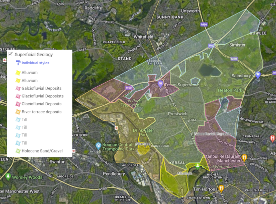
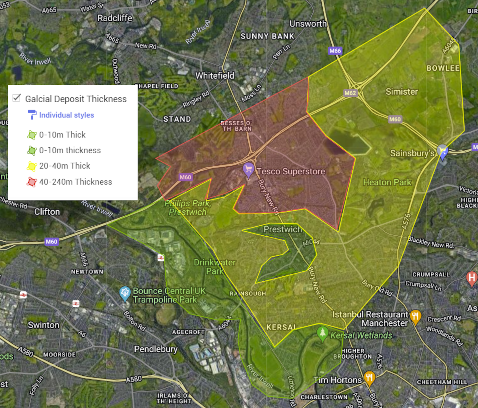
Map showing thickness of superficial geology (deposits) Red upto 240m thick, Green less than 10m.
To look at Geology is to look back not over hundreds of years but over potentially hundreds of millions of years. First though let's just go back a few thousand, to the last Ice Age which ended about 11,700 years ago.
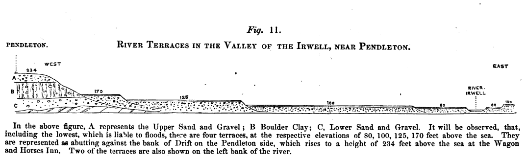
On the West border of Prestwich, the Irwell Valley, we see flat areas of river terrace deposits. The Irwell Valley was carved out by rivers of melt water that flowed as the ice sheets melted, depositing layer upon layer. When they were less vigorous these rivers left behind layers of sandy gravels made of stones dating from the Pleistocene (2.58mya to 11,700 years ago).
All these superficial deposits make the whole area a challenge for construction and subject to erosion and subsidence, though the causes of that may vary. One reason for erosion is that the rivers and streams are still undergoing landscape adjustment following the last glaciation, they are yet to find their way in life.
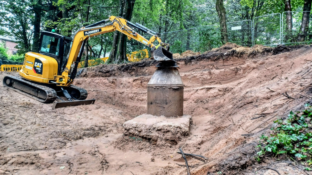
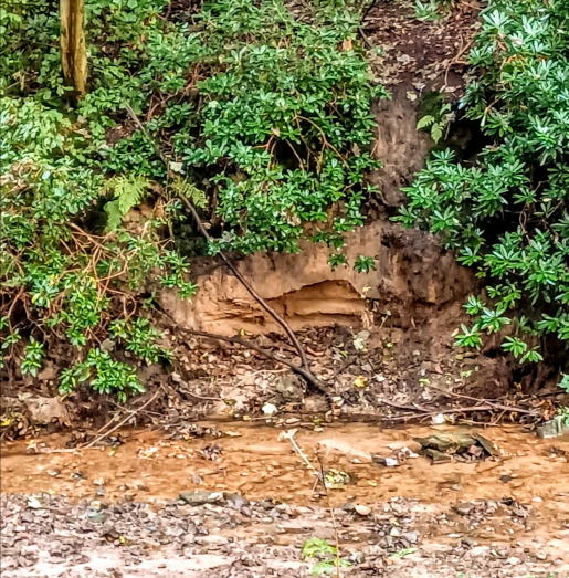
In addition, the natural erosion by rain and streams/rivers can also cause issues, as can be seen by the bank erosion in Prestwich Clough. Though the recent erosion which led to major reconstruction work in Prestwich Clough appears to have been caused by a leaking sewer.
Even in small localities subsidence can be affected by the addition of a thirsty tree/shrub drying out the deposits, and conversely, the removal of a thirsty tree can also cause subsidence as the deposits become wetter. If this happens close to a property or wall then cracks can start to appear possibly leading to further structural issues.
See Part2 for more info about the deeper bedrock formations...
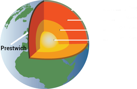
The thin crust of the Earth is continually being replaced by younger rocks through volcanic eruptions on land and under the oceans. Under this crust is the mantle, about 1,800 miles of rock with minerals, iron, magnesium and silicon, all mixed up, hot and molten (semi solid). The mantle moves and along with the pressures pressing down upon it, creates such heat that rock melts. This is what the tectonic plates that make up the crust ride along on top of as they crumple the crust into huge mountain ranges, such as the Alps, Himalayas, and the Pennines !
Yes, the Pennines may once have stood proud and sharp above us, but they have been eroded by giant ice sheets, glaciers and rivers.
The Earth's Structure The Earth's core is about 758 miles of extremely dense and hot metal (5,400°C), surrounded by another 1,300 miles of liquid nickel and iron. This outer core is heated by radioactive decay of the elements uranium and thorium,and is very liquid. This layer creates electric currents and is responsible for Earth's Magnetic field, giving us a very useful magnetic North and South.
The bedrock (solid) crust forms a relatively thin skin, between 15 & 22 miles thick under the British Isles. The thinnest areas of the crust under Britain are in northwest Ireland and Scotland. Above this thin skin of slowly moving rock, there's an even thinner layer of deposits added to each passing year by autumnal leaves and sedimental deposits picked up and dropped off by wind, rain, streams, rivers and floods.
In Prestwich, under the soil of the modern eras, lie layers of sand, gravel and dark grey to grayish brown, extremely compact, stony, sandy and silty clay (called till - this tends to have chunky stones in it rather than rounded pebbles). All this matter is called superficial geology or drift deposits. The 6-8m of sandy gravel we find in Prestwich was left here during the Holocene period, which is only the last 11,700 years.
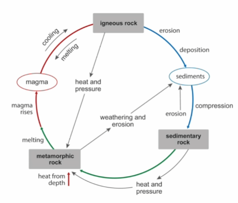
Recycled rocks Though the til clay deposits were left here during the end of last Ice Age (11,700 to 12,900ya) the stones within the till date from the Carboniferous period, 307 to 319 million years ago (mya). The earth is 4,6Bn years old (4,600,000,000) and the Rocks have been through the mangles of eruption, quake, erosion, burial, melting several times before they arrived where they are today. It's very rare to find a rock that is as old as the earth due to this constant recycling.
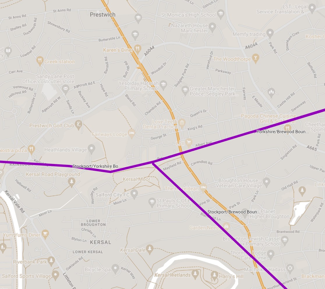
These glacial deposits under Prestwich are called Yorkshire Till, as it was deposited by an ice sheet flowing from the Yorkshire Dales. The Yorkshire ice sheet met other ice sheets originating from the Irish Sea at what is now the southern boundary of Prestwich. This boundary runs along the course of Singleton Brook, Kersal Moor & Broughton Park, to Castle Hill on Bury Old Road.
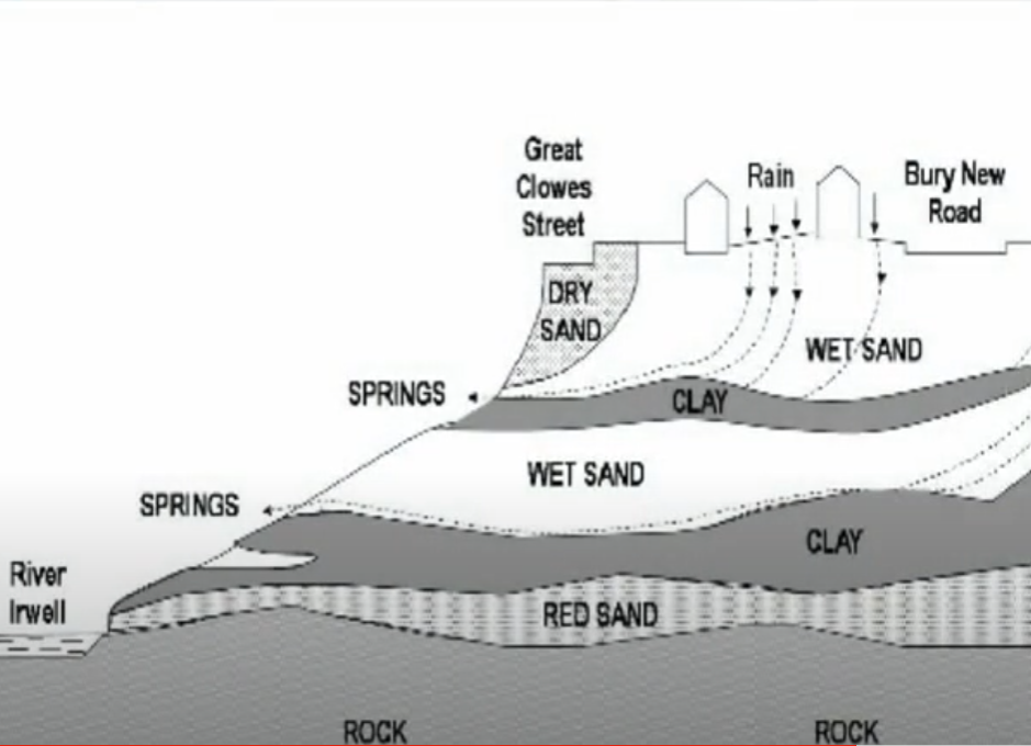
Any 2D map of what lies beneath is misleading as you really need to think in 3D. A layer of sand can be covering a layer of clay, which in turn covers a layer of gravel, covering a layer of sand...on so on. Two gardens in the same street could have differing deposits underneath especially if there is a height difference between the two.
In addition, some areas of boulders, gravel, sand, silt and clay (called Glaciofluvial Deposits) that have been transported, sorted and deposited by streams of water following the melting of the ice sheets, lie to the north of Philips Park (Mere Clough), beneath the Papal field in Heaton Park and under most of Sedgley Park.
The thickness of the glaciofluvial deposits under Prestwich vary from less than 10m for the river terraces in the Irwell Valley, to up to 240m thick for the deposits found from Heaton Park towards Philips Park & Whitefield. Stotts colliery, which was next to Stanley House in Whitefield (1855-1902), recorded the drift deposits as 150ft (45m) of sand/gravel.
This deep area of deposits is also referred to as a hidden valley, is full of deposits washed in after the Ice Age. Evidence of how deep the deposits are can be seen in the depth of the Cloughs in Prestwich which never reach solid rock.
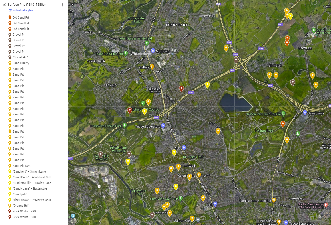
The shallowest deposits away from the Irwell valley are found around the Hope Park area of Prestwich, so if you wanted to open up a quarry, the Friendship car park wouldn't be the worst starting place ! The following map show the locations of surface pits, quarrries and some "sandy" place names.
As an example of the challenges to construction, when the original OLOG chapel was constructed in 1890, a layer sinkingsand was encountered, and the sinking of piles, strong columns sunk deep into the ground, was considered. In addition water
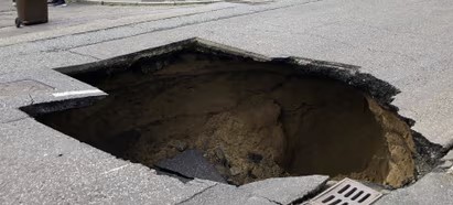
We construct artificial surfaces made from concrete, paving, tarmac etc to make moving about easier, and when the drains underneath the surface fail the drift deposits are washed away leaving a void. When the surface gives way, we end up with what we call a sink hole. It should be mentioned that these are not the same as the dramatic sink holes you see from around the world. Those are caused when voids are created in the underlying bedrock (usually limestone), whereas ours are generally caused by a leaking pipe.
Recent sink hole events on the roads of Prestwich - 2014 & 2016 (Heywood Rd),2017 (M&S),2021 (Lowther Rd,Sedgley Park & Heywood Rd), 2022 (St. Ann's Rd), 2023(Heywood Rd & Whittaker Lane) were caused by failing drains/sewers.
The most dramatic erosion in the Prestwich Area is just over the border in Higher Broughton, at the landslide or "Lanny". At this location the erosion from the River Irwell interacts with the layers of glaciofluvial deposits and periods of wet weather to create an unstable slope. In addition it's claimed that mining activity also had a hand in the landslide (see Part 3)