 Lords
Worship
People
Places
People
Contact
Lords
Worship
People
Places
People
Contact
What Lies Beneath
Part2... info on the bed rocks and formations beneath Prestwich.
Read part 1... info on the superficial geology of Prestwich
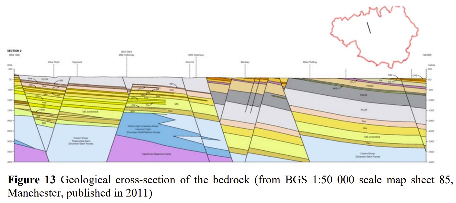
The bedrocks would be quite neat & tidy to look at if they had stayed put, but as shown above, due to geological forces the perfectly neat layers of sedimentary rocks.
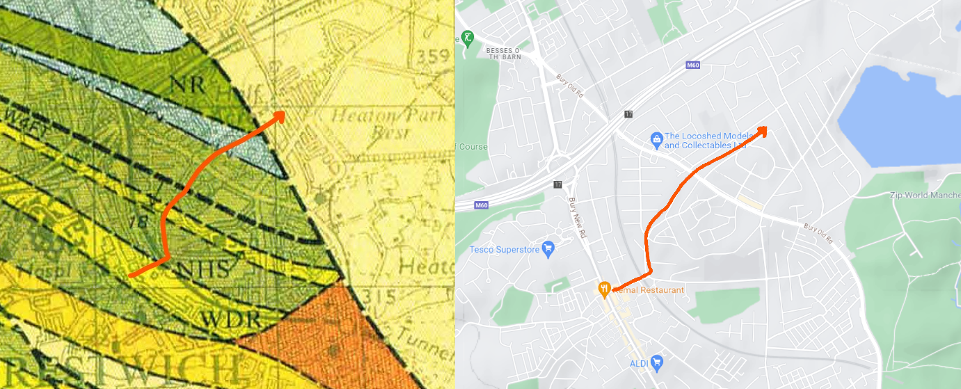
If the 40-240m (130-800 feet) of human surface & glacial sand/gravel/clay deposits were stripped away and you were to walk from Bury New Rd along Fairfax Rd, you would be walking on a layer of Worsley Delph Rock (sandstone). If you then passed under the railway bridge and turned left following Poppythorn Lane, you'd now be on a layer of Newton Heath Sandstone, and then some Westphalian Coal deposits. These coal deposits have seams of coal running through them that we explore in part 3. If you then continued along Poppythorn Lane as you approach Guest Rd you'd cross a band of marine fossils. These were left when areas of swampland were flooded. Now at the top of Guest Rd, carefully cross Bury Old Road and head along Cuckoo lane towards Sandgate/Half Acre and you would be walking on a layer of Nob End Rock. All these sandstone rocks and fossils were laid down between 315 and 305mya. You wont actually see any of them though,the only place you would see any of these rocks, apart from in an underground tunnel (see part 3!), would be if you headed down the Irwell Valley, where the river has cut through the glacial deposits.
As well as being physically disjointed from the locations that give the rocks their names, you have effectively walked downwards, through the different rock layers as they would have been originally layered. The Nob End Rocks in the East are older, originally deposited beneath the coal deposit layers and other sandstones. This is true generally in Britain, as you walk form West to East the rocks get older, which is why (generally) you get limestones further East, as these were laid earlier, in the Carboniferous period (359 to 299 mya).
Delph comes from the Old English (12th Century) "delf" meaning Quarry.
Horizontally the formations have been shifted just over 5 miles following along the Northwest/Southeast line of what is now the Irwell Valley.
The Pendleton fault alone has displaced rock formations by about 1000ft non-horizontally (diagonally up/down), with the once horizontal layers of rocks sloping downwards underneath Prestwich as they head south towards the fault line in the valley bottom. Alternatively you could view them as sloping upwards as you head North, but the northern rocks have had their tops sliced off, revealing the older rocks closer to the surface.
Another indication of the upheaval that has been experienced, is that the layers of Manchester Marls (252-201mya), & Bunter Sandstone (260-230 mya) found along the Irwell Valley in Prestwich are also found at Stand Old Hall on Ringley Road in Whitefield, over 300 feet higher and over a mile away from the River Irwell.
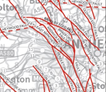
Two more fault lines, the Outwood and Ardwick Faults sandwich that Red Rock Outcrop at Stand. The Outwood fault passes under the centre of Prestwich and heads off to the Heaton Park Railway Tunnel, where it meets the Bradford Fault (reactivated by mining in the 1960s). The Ardwick Fault passes across Prestwich Clough, under Butterstile and across Kersal Moor to meet Bury New Road at the Landslide in Higher Broughton. A 3rd, The Bradford Fault, passes under Simister Island and Rhodes, and finally a 4th, The Bradley Fold Fault passes under Bowlee.
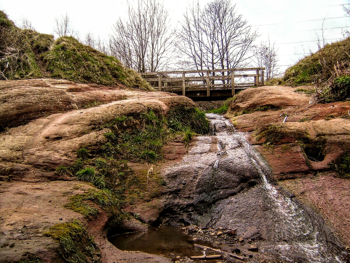
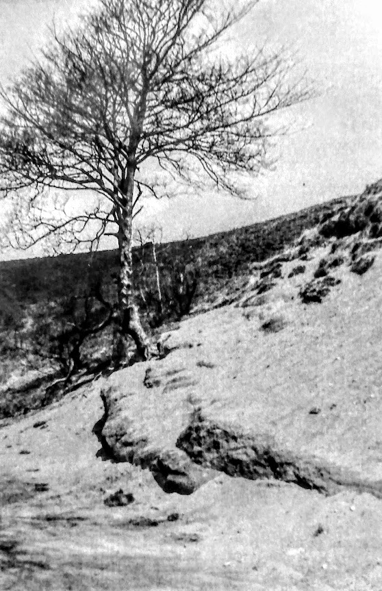
In Prestwich, these sand stones are exposed on the riverbed of the Irwell during dry spells, approx 180feet lower than the centre of Prestwich Village. The rocks can also been seen along the river banks and valley sides.
Far from being formed on a riverbed, these rocks were originally laid down as red sand when Britain sat near the equator, in much hotter desert conditions - indicated by the presence of rare minerals such as halite and gypsum showing evaporation has taken place. These red sandstones also underly Heaton Park and Simister. At least three nearby locations are called Red Rock as a result of these formations (at Giants Seat, Waterdale & The Cliff), and there was an exposed outcrop visible at the entrance to Drinkwater Park from the bottom of Rainsough Brow.
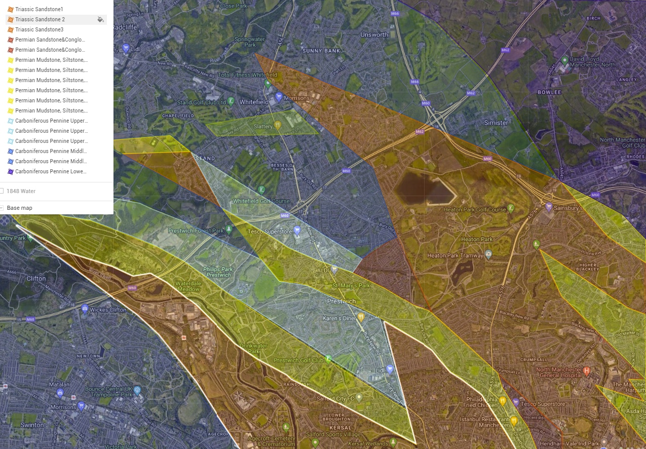
Similar sandstone, Mudstone and siltstone rocks from the Permian period (251- 298mya), are also present under Prestwich, in swathes stretching from Broughton to Outwood, and from Crumpsall to Prestwich Hospital. This layers tends to be between 7 and 70m thick.
The underlying iron from glacial deposits and geological formations, leaves a visible sign in Prestwich Clough whenever the stream turns a rusty orange. In addition what appears like an oily film on the water is another indicator. The film is actually made by bacteria that are reacting to the presence of iron. A simple poke with a stick, if the film cracks, shows it is not oil.
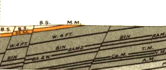
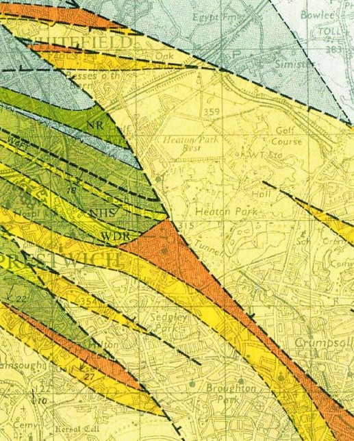
The line marked W4FT on the map above indicates a coal seam worked by the Worsley Four Foot Mine, for more about the mine workings under Prestwich see part 3 - Humans & Nature..
Please note: all diagrams are approximate, do not sell, purchase or worry about what is under your house based on this info !
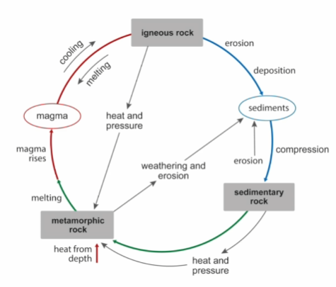
The drift deposits mentioned in part 1 mask the underlying bed rock geology. These bedrocks have not been transported here by mere ice sheets or rivers but have arrived here by much larger forces, over much larger time spans.
Recycled rocks Though the til clay deposits were left here during the end of last Ice Age (11,700 to 12,900ya) the stones within the till date from the Carboniferous period, 307 to 319 million years ago (mya). The earth is 4,6Bn years old (4,600,000,000) and the Rocks have been through the mangles of eruption, quake, erosion, burial, melting several times before they arrived where they are today.It's very rare to find a rock that is as old as the earth due to this constant recycling.
Sedimentary Rock These are rock made of other rocks (Igneous - formed from molten magma, or metmorphic - formed from pressure and heat, or other sedimentary rocks). These other rocks are weathered and eroded into smaller chunks, then transported by rivers, wind or glacias etc. before being deposited in another location, such as in a desert or on the bed of a sea, lake or river. The desposits form layers, some more muddy or sandy or made of larger chunks, depending on the conditions at the time. They are then buried (under more deposits) and compressed unedr the resulting pressure to form sediments.
The youngest bedrocks underneath Prestwich are the Red Sandstones in the Irwell Valley on the Western boundary of Prestwich, these date from the Triassic Period (so are only 252-201mya). We also have Bunter Sandstone (260-230 mya) overlaying the older Manchester Marls (274-251mya), found in a band running from Broughton Park towards Philips Park.
Yeah, but isn't sandstone made of sand, which is made of rock? Yep, sand is made from little pieces of rock. When rocks get eroded and weathered the softer rocks and minerals dissolve into the rain/rivers/seas and blown away by wind, leaving the harder and heavier rocks remain. One of the harder elements is silicon or quartz, in addition iron also remains and so silicon sand tends to be tanned, brown or red due to the ironoxide (rust). Where the local rocks are magma or basalt thrown out from volcanoes, the sand tends to be dark or grey. The white beaches of the Carribean come from calcium-carbonate, the left overs of dead corals from the oceans (technically the corals have been eaten by fish, and the fish can't digest the calcium-carbonate ...so white beaches are made up of fish poo !). The size and shape of the grains also tells us if the sand/sandstone was deposited quickly, in a flash flood, or slowy by the desert winds, or how far and how logn the grains have been travelling. If sand is about 95% silicon/silica it can be used to make glass.
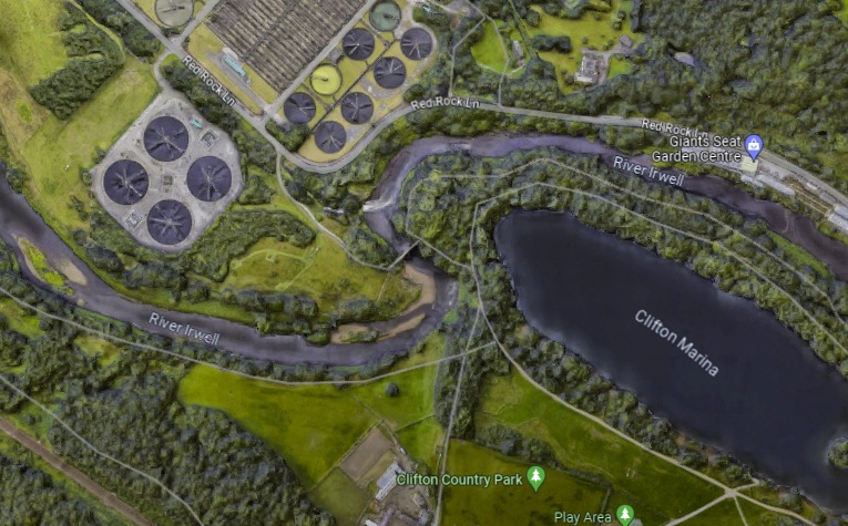
The main fault line near Prestwich passes along the Irwell Valley, and is called the Pendleton, West Manchester or Irwell Valley Fault. This fault line gives us the impressive "s" bend in the river at Clifton Country Park as the river flows from one side of the fault to the other.
As mentioned, The youngest bed rocks under Prestwich date from the Triassic Period (201-251mya), and they are called "new red sandstones". The Triassic period both started and ended with mass extinction events, and some important fossils have be found in these layers elsewhere in the country. Sometimes also called "Helsby Sandstone", it has been found to be upto 140m thick.
Watch how the UK has moved over the last 450 million years...
These Permian sandstones tend to get used for construction in the region, with Manchester Cathedral, Chetham's School, and of course our very own St Mary's Church being made of what is called Collyhurst sandstone. The quarry was just off Rochdale Road in Collyhurst, and is now called Sandhills. The stone is a fine to medium grained sedimentary rock, created from desert sands blown into dune formations during the Early Permian period when the area which now constitutes the British Isles was within the desert belts to the north of the equator. The rock is not very resistant to weathering and erosion and disintegrates relatively quickly.
Even older than the Permian Period stones are those from the Carboniferous Period (359 to 299 mya). These comprise of more sandstone, siltstone, mudstone and ironstones - sedimentary rock with more than 15 % iron.
Further back in time we come across Carboniferous formations, formed during the Paleozoic Era (252-538mya) Carboniferous means "coal-bearing", from the Latin carbō ("coal") and ferō ("bear or carry"). Terrestrial animal life was well established by the Carboniferous Period (359 to 299 mya), and marine fossils are also present in these rocks. However the coal itself is made from dead plant matter which was abundant durign this period This matter initially created peat, then was buried and compressed deep underground to form coal. These layers are found to be between 300 to 800m thick.
Between the swathes of the Triassic rocks (orange on the above map) dating from 252-201mya, we find swathes of Pennine Upper Coal deposits (grey/green) with bands of rock such as Worsley Delph/Newton Heat/Nob End Rocks (shown in green).These Carboniferous bands of rock date from 307 to 319mya, and are 300 to 800m thick. These formations run along a Northwest/Southeast line from Broughton Park, via Butterstile to Outwood.
To our North and West lie Pennine Middle Coal deposits, as well as coal, these are also siltstone, sandstone, and ironstone, running about 200-650m thick. This layer is sat "on top of" a bed of mudstone containing marine fossils. "On top" loses it's meaning when rocks have been thrown around like ours, as does thickness. In fact geology is a bit hit and miss because of all the displacement.
To the North and East of Prestwich lies Pennine Lower Coal, a mix of mudstone, siltstone and pale grey sandstone, with rich coal seams towards the "top". These deposits are about 307 to 319mya, and are found to be 650-720m thick.
.
See Part3 for more info about Humans & Nature...