 Lords
Worship
People
Places
People
Contact
Lords
Worship
People
Places
People
Contact
Gardner Mount
Back in the tithe maps of 1839, what is now Gardner Road was just a field boundary, with a meadow called Flat field lying to its North, under what is now Leach Street and Ernest Street.
To the south of Gardner Road lay a pasture called Swine Park, both fields were at that time owned by George Gardner. The field name hints at the rural history of the area, indicating how the local soil wasn't much use for arable farming (crops), but more suited to pastoral farming (animals). Also indicated by nearby Hardman's Fold/Green - a hardman was a herd man. Though some fields were set aside for potatoes, oats, turnips, many were set as meadow land providing food for the animals such as clover or hay.
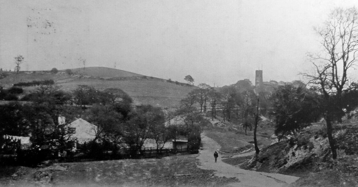
Clough Lane ran up to Clifton Rd along what became the rear boundary of the houses on Leach Street, and it wasn't until later in the 19th century that a dirt track appeared linking Clough Lane through Greengate Farm, at the junction of Warwick Street, onwards to the village.
George Gardner was a major land owner in Prestwich, when he was recorded in the tithe returns of 1839. He owned 230 acres, making him the 2nd largest land owner after the Earl of Wilton who owned 26 acres more.
George owned all the land West of Gardner Road, down towards the bottom of Prestwich Clough, East to Hamilton Rd on St Ann's Rd, and a swathe of Butterstile Hill from Sandy Lane down to the bottom of Rainsough Brow.
In 1841 the census records that a George Gardner Esq. (b:1786) was living at The Priory in Pendleton, which was a large house that stood in substantial grounds. A nearby street still bears the family name.
George Snr. had been a dry salter by occupation, dealing in crude dry chemicals and dyes, having retired by 1841, he had died by 1845 and left his estate to his three sons George, Thomas and William.
Back in Prestwich... George (Jnr) was recorded as an overseer of Prestwich in 1840 and in the census of 1841, a George Gardner (b:1816) living on independent means was recorded living at the house of John Gaskell (b:1811), at Prestwich Hills (previously known as Diggle Fold). Also present at the house were a farmer and his wife, William and Sarah Massey.
(The name Prestwich Hills later transferred to a house that stood beside Eagles Nest on Butterstile Lane.)
George set about building a road over Butterstile Hill, linking the top of Rainsough Brow to Bury New Road at Thorndyke, and called it Gardner Road. He got his return on his investment by charging people to use his road - Gardner Road. This was renamed Butterstile Lane in the early years of the 20th Century, and freed up Gardner Road to be used at Gardner Mount instead. Until around the end of the 19th century Butterstile Lane had just been the name of the lane from Bury New Road to its junction with Shrewsbury Rd.
William Gardner had already sold Parkin field to the Leach brothers of builders and joiners in the 1890's, and James Leach was already living at 3 Gardner Rd by 1891. His brother was at 31 Warwick Street nearby.
The field to the north of Flat Field/Walter Street was called Daub Field, and had been owned by Oswald Milne. He had already sold 50 acres to the Lancashire Asylum and The Mount & Wood Villas had already been built on Daub Field by 1891. Daub Field was not part of Leach's plans for the mass housing the country was in deep need of.
Gardner Mount had taken on the name of Spioen Kop after a hill (Kop) that the Royal Lancashire Regiment had fought to defend during the 2nd Boer War in January 1900.
The gate posts to the parkland at Gardner Mount (1906) still stand today and are of a similar style to those that stand at the Lowther Rd entrance to the Clough.
In 1921, the same year that the formal War memorial cross was constructed at St Mary's church, a memorial cross was placed at Gardner Mount, funded and placed by the families of the fallen soldiers of World War I. Communities did not wait for the drawn out process of design, approval & construction of formal memorials, and took it upon themselves to create temporary memorials from wooden posts, planks or beams. These obviously rotted over time, but the one that stood on Gardner Mount, now at PADOS, is thought to be a rare if not unique survivor. It was moved to PADOS in the 1970's due to vandalism.
At the West end of Gardner Road a barrage balloon was set up to protect the approaches to the factories that sat on the valley of the River Irwell. A further balloon point was located at the bottom of Prestwich Clough.
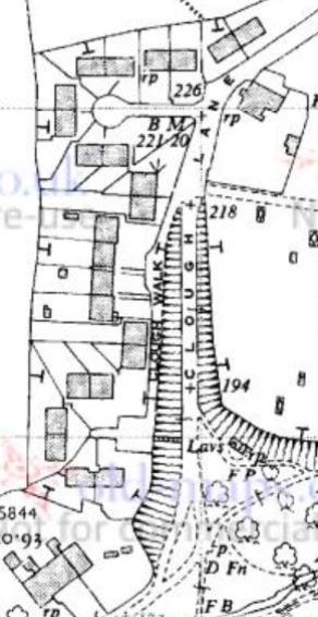
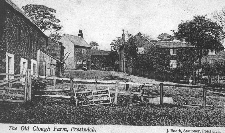
As you head down Clough Lane the field to the right (West) was called Sheep Pasture (above it was Old Meadow), towards Clough Farm the field on the left (East) where Incredible Edible are now, was called Smithy Carr. Smithy suggests someone once worked metal there, and Carr suggests it was overrun with bushes and brushwood as opposed to an open meadow.
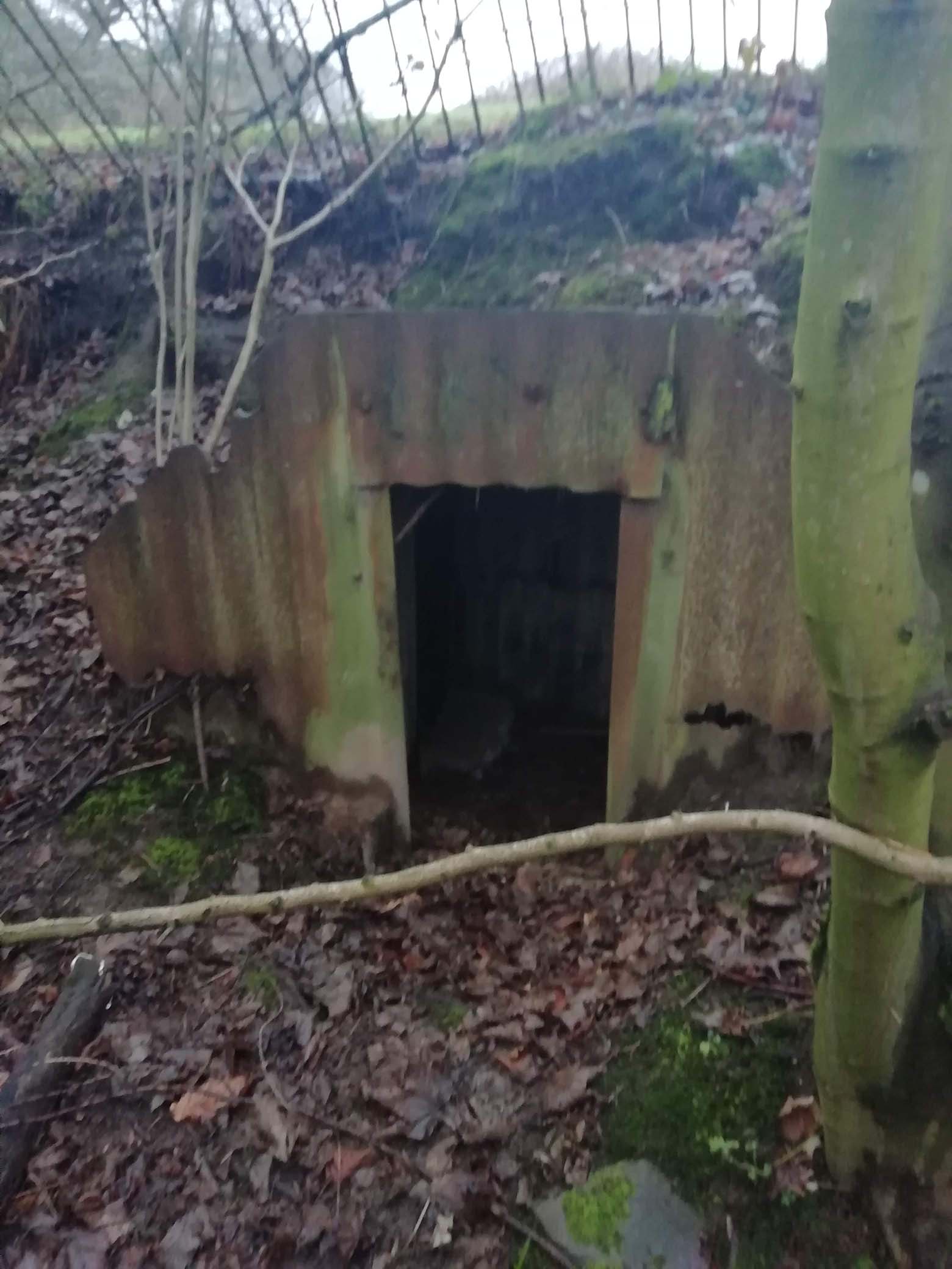
On the right hand side just as you approach Clough Farm was a small estate of 25 houses called Clough Walk, constructed in the 1930s. You can still find one of their WWII Anderson shelters dug into the side of Sheep Pasture.
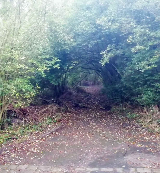
Opposite the farm was a cul-de-sac and you may just spot the kerb stones of the pavements in the undergrowth.
Clough farm has been held by several farmers:
The houses suffered when the Coal Board ran a railway under the Clough and they were demolished sometime around the 1960's.
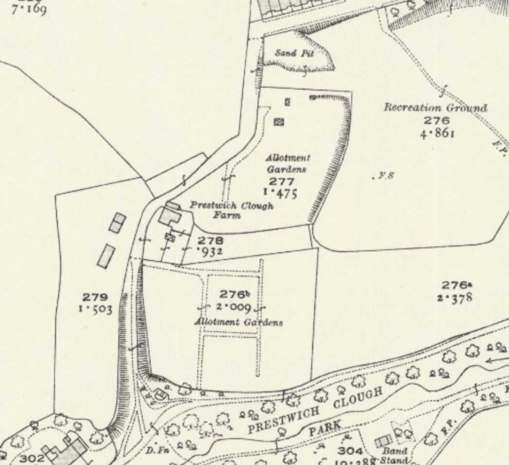
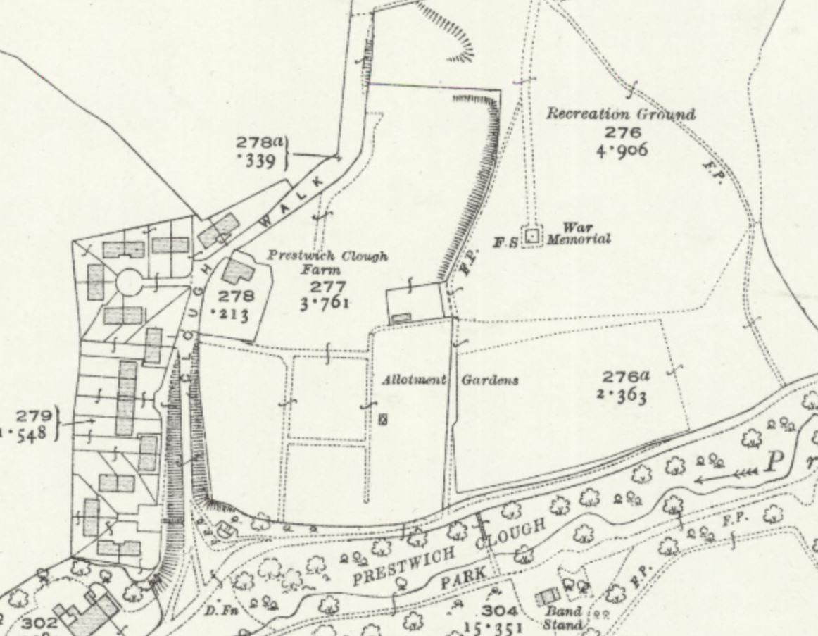
Below Clough Farm and where the allotments are today was called House Meadow, the allotments were constructed on this meadow and the Smithy Carr meadow (above the farm house) shortly after WWI to help returning soldiers and local residents.
These were known as North and South Clough Allotments as the farm had kept a slice of land between the two to maintain access.
Both allotments merged in the 1930's and also expanded East along the top path of the Clough leading to a small 1 acre pasture below Swine Park, called Clough (Could this be the original Clough that Prestwich Clough was named after?). After WWII the north allotment fell into disuse and the eastern extension had followed by the 1960's.
However by 1906 it was William Gardner who was the last man standing and had inherited the estate from his elder brothers and he sold the 13 acres of Gardner Mount (by then also known as Spion Kop) to the council along with a donation of 9 acres that forms today's Prestwich Clough. William appears in the 1901 census, living at Prestwich Lodge in a wealthy suburb of Cheltenham, aged 80. Just to complete the circle back to Pendleton, Cheltenham St has a junction with Gardner Street, not far from the Priory Arms Pub.
William Gardner also sold Flat Field, the field between Clough Lane & Green Gate, to James & William Leach, joiners and builders, about 1903.
William Leach died in 1936 aged 75 and Norman his son had died the year before aged 35, both are buried in St Mary's churchyard, with William's parents John & Mary who had died in 1886.
James Leach died in 1939 aged 82 and is buried St Mary's churchyard. His son, Ernest, is also buried there having died in 1922 aged 36.
Land to the west of Leach Street (Old Meadow) was not developed for housing as it belonged to Lancashire County Council as part of Prestwich Asylum, and remains as farm land today.
The hill of that name is now in modern day South Africa, and its name translates as spy hill, or hill with a good view. The battle had been subjected to major blunders by the British commanders when twenty thousand soldiers were misled up a hill, only to find themselves not on the high ground after all, and the enemy over looked the Lancashire trenches, leaving the soldiers with no where to hide.
The battle ended in defeat for the British as the Boer snipers and artillery took their aim. Three Hundred and thirty soldiers died and 1,000 were wounded and similar to "The Grand Old Duke of York" the soldiers had to retreat back down the mountain. In memory of their fallen pals, returning soldiers named steep or high places "Kop", such as the large football stands at Anfield, Hillsborough and Elland Road. Local soldiers must have drawn comparison to the hill with great views over the Clough to the Irwell Valley beyond, and the name stuck for some years until it was renamed Gardner Mount after the land owner.
Credit:Renier Maritz - Own work, CC BY-SA 3.0, https://commons.wikimedia.org/w/index.php?curid=563027]
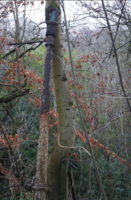
Jumping to the 2nd World War, the mount became the location of an air raid shelter, you can just make out the "dog leg" shaped dips in the ground where it once stood.
It would have been made of concrete and buried under soil with a wall across the entrance to stop any blast coming inside.
Because of it's commanding views over Prestwich, the location was also used by the Home Guard during WWII as an observation post. A map shows the distances of main landmarks from the Kop, which would be useful for setting the range of artillery or mortars in the event that the Germans were foolish enough to invade Prestwich.
One windy day during WWII, the Barrage balloon stationed on the field at Gardner Mount broke loose and ran it's chains along the rooftops, and you can see the shortened chimney at the end, and missing pots.
Gartside (1754)
Leake (1841)
Rayner (1851)
Knott (1861-1891 known as Knotts farm).
By 1911 there was a new farmer in residence at Clough Farm called William Smethurst.
On the right, near the vehicle barrier, you can find some precarious steps that lead up to an old lamppost and the site of the council housing.
Read more about the the allotments
In 1946 the council Parks Committee decided to convert Gardner Mount which was being used by locals as a land-fill tip, into a formal recreation field.